
TRG SLOBODE

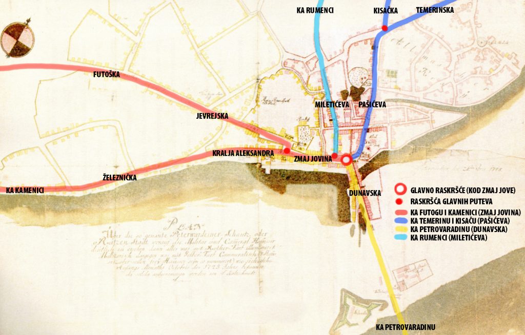
Trg Slobode became the main square of the city soon after the city was founded. It was constructed on the Y intersection of the road to Futog and the road to Kamenica, that continue together as Zmaj Jovina Street. Futoški put comes to Trg Slobode, via Futoška, then Jevrejska ulica and Pozorišni trg. The former road to Kamenica, led to the Kamenica ada, where boats crossed into Kamenica. Today on this direction are the following streets: Lasla Gala, Zeleznicka, Trg Mladenaca and Kralja Akeksandra to Trg Slobode.
Trg Slobode was once known as the “Velika pijaca (the Great Market)”, as it continued on Zmaj Jovina Street, which was then simply called Pijaca, the Market, (it also bears that name on the city plan from 1745). Later, it was called the Main Square for a long time, and under that name it is also mentioned by the German travel writer Siegfried Kapper, who visited Novi Sad a few months after the bombing in Buna in 1849:
“From the main square, where the old, dilapidated Town Hall was the only house spared the flames… I headed towards the main square again. In the middle of that square rises the Holy Trinity surrounded by greenery, and a few steps from it was a one-story, half-ruined house… It’s the old Town Hall.”

According to Sauter’s plan of Novi Sad from 1889, at the time Trg Slobode is still called the Main Square (in Hungarian and German). The name refers only to a part of the square next to the Catholic church (marked in red):

On Sauter’s plan, we see the most important building in the city marked in black, with inscriptions. On the Trg Slobode are marked the following buildings: Hotel Elizabeth, which still works today as Hotel Vojvodina, then on the opposite side is Hotel Kronz, on the site of which the Grand Hotel Mayer was soon built, as well as the old palace “Iron Man” with the inscription Sparkasse. The old Catholic church was also marked, and in its place the Cathedral will be built 5 years later.

Trams operated on the square from September 30, 1911, until the same day in 1958, when it was abolished. There was a Y intersection with Line 1, known as the white line from Futoška Kapija to Temerinska Street, and Line Two, a green line that went from the former railway station to the end of Dunavska Street, which was the bank of the Danube.

Trg Slobode has not changed its name for almost 200 years because it was the main city square and it was called the Main Square, but on the city plan from 1900 we see a new, politically colored name, Franz Josef Square (then Emperor). After World War I, it was renamed Trg Oslobođenja, and during the occupation in World War II, the name was changed to Trg Državne zastave (in Hungarian), and after the war it was renamed to Trg Slobode, the name it still bears today.

The realisation of this site was supported by the Administration for Culture of the City of Novi Sad

The sources and materials of the Institute for the Protection of Cultural Monuments of the City of Novi Sad were used for the realization of this website
The Old Core of Novi Sad was declared a cultural asset, by the decision on establishing it as a spatial cultural-historical unit – 05 no. 633-151/2008 of January 17, 2008, “Sl. gazette of the Republic of Serbia” no. 07/2008.


