KRALJA ALEKSANDRA STREET

This is the former Main Street, which, across today’s Trg Slobode, continued towards Zmaj Jovina (that used to be simply called Pijaca – the Market). The street is located on the route that used to lead from to Kamenica, and later to the train station.
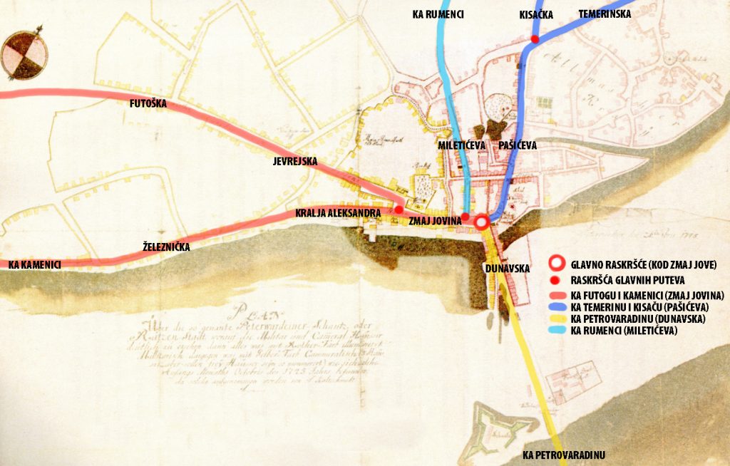
Novi Sad was built at the crossroads of 3 roads that met at the Zmaj Jova’s monument in front of the bishop’s palace. From the crossroads to the west, through Zmaj Jovina (Main Street), there is a road to Futog and Kamenica, which diverge on today’s Trg Slobode, at the City Hall, to the left (Kralja Alesandra Street) and to the right (old Jevrejska and Futoška Street). From the crossroads to the south, through Dunavska Street, there was a road to Petrovaradin over the pontoon bridge and further to Belgrade, and to the north, through Pašićeva, a road to Temerin (Temerinska Street), and further to Budapest. At the end of Pasiceva street, there used to be an old Inn called “At Three Crowns”, just as the road turned to Temerin, and also the road to Kisac (Kisacka Street) used to separate here. Somewhere in the middle of Zmaj Jovina Street, to the north, another old road separates – the road to Rumenka which leads through Miletićeva Street, then Vojvode Bojovića and Kralja Petra, to Rumenačka Street.

Today’s Kralja Aleksandra Street was first called the Main Street (on the city plan from 1745), and later for a long time Gospodska Street (as we can see on Sauter’s city plan from 1889), and led to Kamenicka Ada, from where boats crossed to Sremska Kamenica. Gospodska Street stretched further across Trg Mladenaca and Železnička Street, all the way to the end of Lasla Gala Street.
Later, this street led to the railway station (today’s Limanska pošta building), and that is why one of the streets in this direction is called Železnička Street. In the next picture, we see this street marked in red on Sauter’s plan of Novi Sad from 1889.

In this plan, we see the Royal State Gymnasium at the place where the Bazaar is located today. The other representative buildings in this street are: the Dundjerski Palace at number 3, the old Adamović Palace at number 4 and the Menrat Palace at number 14. These buildings are described on this web site in separate articles. The house numbers on Sauter’s plan are completely different, because at that time every house in the city had its own unique number, which was not tied to the street.

This is one of the streets used by trams from September 30, 1911 until the same day in 1958, when it was abolished. Line two passed here, known as the green line, and it went from the former railway station to the end of Dunavska Street, which was the bank of the Danube.
The street changed many names, from Main Street on the city plan from 1745, through Gospodska Street on Sauter’s city plan from 1889, to an unusually large number of name changes in the next hundred years: Košuta Lajoša Street from the end of the 19th century to 1918, 1918-1941: Regent Alexander and then King Alexander, 1941-1944: Hitler Adolf utca 1944-2000: King Alexander, Generalissimo Stalin, Alexander Ranković, People’s Heroes, and again Kralja Aleksandra Street, as it is called to this day.


