PASICEVA STREET

This street is perhaps the oldest in the city, because there are archeological finds from the Middle Ages, and its first recorded name “Vel’ka čaršija” can be found on the city plan from 1745, among only 9 registered names (this is one of two names in Serbian, 1 in Hungarian and 6 in German). There was a Turkish Han on the site of the Matica Srpska building, which together with the name may indicate a settlement before the arrival of the Habsburgs. Medieval sources from the 12th to the 15th century mention the oppidum and the settlement of Stari Petrovaradin, on the Bačka side across the road from today’s Petrovaradin fortress, probably right here on the Zlatna greda region.
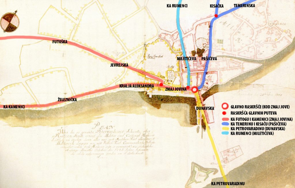
On the next engravement from 1698, at the end of the earth bridge (on the site of today’s Danube Street) on Petrovaradin direction, we see the road splitting into 3 streets that formed a town: straight ahead was today’s Pasiceva, on Temerin and Budapest direction, to the left Zmaj Jovina in the Futog direction, and to the right the Zlatne grede Street, which ended in the swamp.

As we can see, Novi Sad was built at the crossroads of 3 roads that met at the Zmaj Jova’s monument in front of the bishop’s palace. From the crossroads to the west, through Zmaj Jovina (Main Street), there is a road to Futog and Kamenica, which diverge on today’s Trg Slobode, at the City Hall, to the left (Kralja Alesandra Street) and to the right (old Jevrejska and Futoška Street). From the crossroads to the south, through Dunavska Street, there was a road to Petrovaradin over the pontoon bridge and further to Belgrade, and to the north, through Pašićeva, a road to Temerin (Temerinska Street), and further to Budapest. At the end of Pasiceva street, there used to be an old Inn called “At Three Crowns”, just as the road turned to Temerin, and also the road to Kisac (Kisacka Street) used to separate here. Somewhere in the middle of Zmaj Jovina Street, to the north, another old road separates – the road to Rumenka which leads through Miletićeva Street, then Vojvode Bojovića and Kralja Petra, to Rumenačka Street.
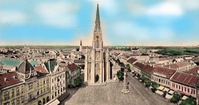
At the very beginning of this street, there is the Serbian Orthodox Cathedral, next to the intersection of three main roads. As early as 1698, a Serbian military garrison was stationed in Racka Varoš, and the Srbian Orthodox Bishop of Backa was ordered to move the seat of the diocese from Szeged, where it was during the Turkish rule, to today’s Novi Sad. In the Middle Ages, cities were mostly built at crossroads and near episcopal seats, and with this decision of the Habsburg Court, Novi Sad fulfilled both of these traditional conditions for the development of the city.
In 1703, a Serbian primary school was built next to the church, then in 1731, the Latin school of Bishop Visarion was built in its place. In 1781 it became the Serbian Orthodox primary school.
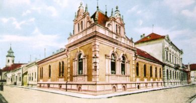
At the corner of Pasiceva and Zlatne grede Street, is the Platoneum building, the endowment of Serbian Orthodox Bishop Plato. This building now houses the Vojvodina Academy of Sciences, and diagonally across the street is the house of the Novi Sad philanthropist Marija Trandafil, known as “at the icon”.
At the end of Pasiceva Street, on the site of the former Turkish Han, which was completely destroyed in the bombing of the city in 1849 during the Buna, is the Matica Srpska building. It is the endowment of the benefactress Maria Trandafil to the city, as the “Maria Trandafil Institute for Serbian Orthodox Orphans in Novi Sad”.

This is one of the streets used by trams from September 30, 1911 until the same day in 1958, when it was abolished. Line One, known as the white line from Futoška Kapija to Temerinska Street, passed through the Pasiceva Street. This line went from the spa and hospital along Futoška Street, Jevrejska, Zmaj Jovina next to Vladičin dvor and then along Pašićeva Street and Temerinska to the canal, where the line ended

This street from 1745-1918 changed several names: Velika čaršija, Ćurčijska ulica (Kurshnengasse, Szucs utca), Gabona utca, then from 1918-1941: Nikola Pašić Street, from 1941-1944: Jokai Mor Street, from 1944-2000: Nikola Pašić Street then Svetozara Markovića Street, and since the 1990s again Pašićeva Street.